Digital twins are an excellent tool that can be used to create what-if scenarios and enable data-driven decision making, which will be explored by the Council and others.
Introduction
A digital twin for Bradford has always been an aspiration, however this is where Bradford firmly takes a step forward into the Digital Twin, Digital Revolution.
We are doing this for a list of reasons/purposes which include:
- to stimulate investment
- better management of the city
- disaster management
- urban planning
- visualisation - Public participation and potential for better democratic purposes
- augmented reality
- tourism
- encourage the use of the digital clone as an educational resource.
As time moves on there will be many more applications.
The challenge
In 2017 Bradford signed up to a European Union funded project, Smart Cities + Open Data Re-use (SCORE), which is a partnership between nine cities and three universities including Amsterdam, Aarhus, Aberdeen, Bergen, Bradford, Dordrecht, Ghent, Gothenburg, Hamburg, University of Amsterdam, Aarhus University and University of Bradford. Collectively the partners develop innovative solutions based on open data and focus on sharing insights and methodologies for developing better public services.
The challenge was to create an open source, free from copyright, digital twin of Bradford that can be maintained by the Council and others. This essentially creates a 4D digital twin of Bradford to adapt to the dynamics of a richly diverse and evolving city. The digital twin will also have its own open-source data sharing platform that will be available to download free of charge from GitHub. All of this ensures that this challenge can be replicated elsewhere in the world.
Consultancy companies often create these digital twins on behalf of councils, as part of other projects/tenders. However, these are normally subject to copyright, are subject to vendor lock-in, and are therefore restrictive for local authorities to maintain. A council producing its own, open source, free from copyright, maintainable digital twin has the potential to facilitate reinvestment and expansion of the digital twin.
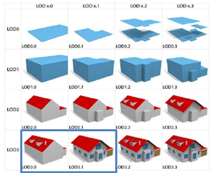
Figure 1 - Hybrid LOD3.0/3.1 approach adapted from Biljecki et al 2016: An Improved LOD specification for 3D building models, Computers, Environment and Urban Systems, vol 59, pp25-37
The tender that was won by the University of Bradford to create a LOD3 digital twin of the city will see the area shown within the following map captured. Whilst the boundary of the original brief was defined by the inner ring road, the University highlighted the significance of buildings just outside the boundary, inclusive of the National Media Museum, Alhambra Theatre and the new ‘Bradford Live’ music venue and agreed to expand the area at no extra cost.
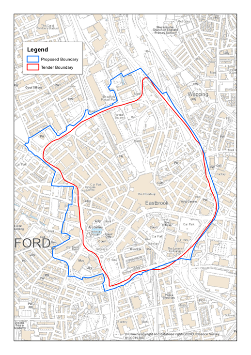
Figure 2 - Revised boundary of the digital twin
The bespoke technology solution being used to create the digital twin draws from a range of conventional and immersive imaging capabilities that enable capture both from the air and from the ground, accurately georeferenced with the use of mobile mapping and GNSS positioning.
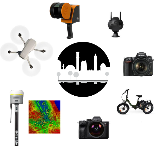
Figure 3 - Imaging capabilities used to develop the Virtual Bradford digital twin
Little Germany is a Conservation Area within the heart of the city of Bradford that includes many buildings with individual listing for their historic and architectural significance. The steeply sloping site was chosen as a test case in the refinement of methods, both to take account of building levels relative to the terrain, as well as the complexity of roof-lines and windows as architectural details that needed to be captured.
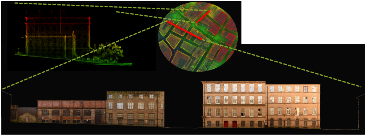
Figure 4 - example building elevations and terrain data derived from photogrammetry and LiDAR data
Outputs and lessons learned
The approach has proven to be unlike any other related commercial contract that the Council team have previously entered into, with the ongoing partnership representing so much more since the team delivering this are based in Bradford and they want the best for the City.
There are some immediate use cases which the Council want to explore using the Digital Twin for in our efforts to be the UK’s leading clean growth city district. These include:
- Northern Powerhouse Rail, which offers potential for a new railway station within Bradford as part of an aspiration to transform the North’s economy with provision of efficient rail connectivity. A potential infrastructure project of this scale will require a significant amount of master planning which will require visualisation and analysis in 3D.
- Helping to deliver the aspirations of the Planning White paper, with the move from 2D to 3D.
- Potential for reinventing retail and urban centres using what-if scenarios and enabling data-driven decision-making. Examples of these being:
- Transforming Cities Fund
- Top of Town development
- Visualising the Air Quality Model for the Clean Air Zone. Although as a Council we can create a Level of Detail (LOD) 1.0, the new digital twin will add so much more value.
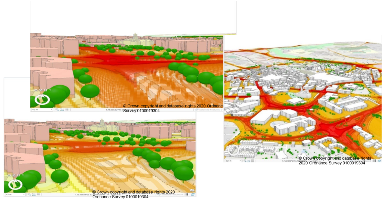
Figure 5 - use of extant LOD1.0 model for air quality modelling (source: ‘copyright Bluesky International Ltd 2021’ and Bradford Council)
Key differences between the ‘Virtual Bradford’ digital twin and other exemplars are that:
- There is no vendor lock in.
- All data will be provided in CityGML format which is an open format and provided in latitude/ longitude.
- All the data will be provided through the Open Government Licence.
- The code for the Open Source platform that will be used to share the data will be made freely available on GitHub.
- Unimpeded access to the digital twin will help to stimulate growth, regeneration and innovation in and for Bradford.
- The digital twin will hopefully be maintained by anyone that can satisfy the specification. This includes Council staff, developers and other stakeholders.
- Because the data is going to be made freely available to anyone, the uses are only limited by one’s imagination.
The potential to stimulate growth, regeneration and innovation in and for Bradford is ultimately the aim for the digital twin. Whilst work is still in train to deliver the Virtual Bradford project it is not yet possible to realise or measure the full impact of the digital twin. However, it is already apparent that the digital twin will have a multitude of uses far beyond those that the Council originally envisaged. The Council will endeavour to return to this document and update it in 12 months.
Links to relevant resources
Contact
Adrian Walker (Bradford Council) or Andrew Wilson (University of Bradford)